## Accommodation in Dikgaleslokasie
Currently, no properties are formally listed in Dikgaleslokasie, which reflects the village's character as a working residential community rather than a developed tourist node. Visitors seeking to base themselves in this area will need to draw on the wider district's accommodation stock, primarily found around Phalaborwa to the northeast and along the game reserve fringe to the east.
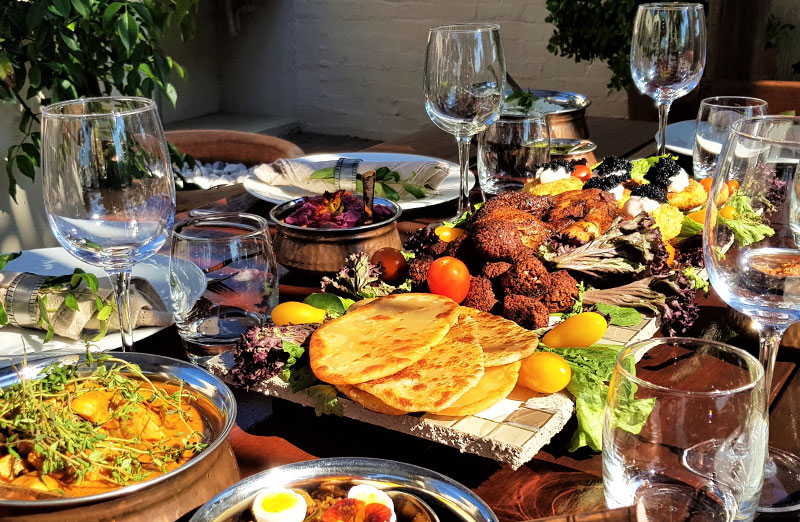
At the budget end, community guesthouses and basic rest camps sit across the rural district. These offer simple rooms, sometimes with shared ablutions, at modest rates. The experience is informal. Hosts at smaller establishments will often prepare traditional meals on request, and carrying cash is advisable since card facilities are not guaranteed at many rural properties. Travellers at this tier generally spend most of their time outdoors, using a room mainly for sleeping and storage.
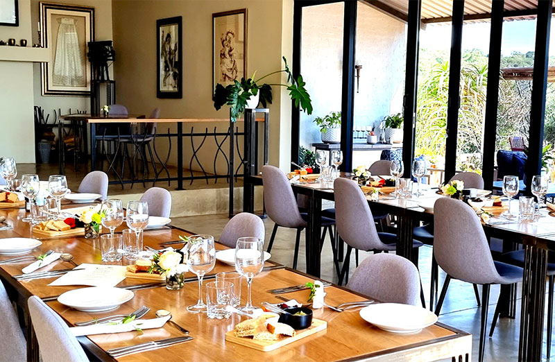
The mid-range tier opens up considerably around Phalaborwa and on the farms and smallholdings between town and the Kruger buffer zone. Self-catering cottages and farm stays in this bracket come with equipped kitchens, braai facilities, and private outdoor space. They suit families or small groups wanting practical comfort without committing to a structured itinerary. Many are owner-operated, which means the local knowledge on offer is often more genuinely useful than anything a booking platform summary can provide.
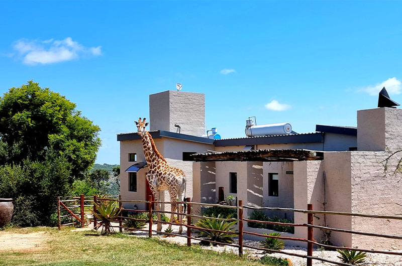
Upper-tier accommodation moves toward the game reserve corridor, where safari camps and bush lodges provide guided activities, catering, and more polished facilities. Properties at this level often sit within or adjacent to private conservancies, offering access to game and guiding that self-drive routes cannot replicate. This tier suits travellers whose primary goal is an organised wildlife experience from the moment they arrive.
For practical searching, a radius anchored on Phalaborwa will surface the most useful options. Properties within 30 to 40 kilometres allow reasonable day access to Dikgaleslokasie and the surrounding communities without requiring you to navigate unfamiliar rural roads after dark.
---
## Best Time to Visit Dikgaleslokasie
The climate follows a clear subtropical pattern. Summers run from November through March, bringing temperatures that regularly exceed 30 degrees Celsius and afternoon downpours that green the landscape quickly. Mornings stay clear even during the wettest months, but the combination of heat and humidity makes extended midday activity tiring. Game viewing in the broader reserve belt is more challenging in summer, as dense vegetation reduces visibility considerably.
Winter, from April to October, draws most visitors. Daytime temperatures are comfortable, nights cool enough to require a jacket, and the dry conditions strip back the vegetation to reveal the underlying terrain. This is when wildlife spotting becomes most productive across the district, and the period from June through August represents peak season. Accommodation in surrounding towns books out during school holiday windows, so planning ahead matters if your dates fall in July.
April and October occupy useful middle ground. Post-summer rainfall tapers off through April while the landscape still holds green from the wet season, avoiding the full heat. October sees birdlife at its most active as the first summer migrants return. Both months work well for travellers who want reasonable conditions and fewer visitors. Those interested in the agricultural character of rural communities in this district may find the quieter post-harvest months from May onward the most rewarding period for an unhurried visit.
---
## Getting to Dikgaleslokasie
The closest commercial airport with scheduled service is Phalaborwa Airport, approximately 60 kilometres northeast of Dikgaleslokasie. Flights connect from Johannesburg's OR Tambo International several times weekly, making this the most practical entry point for air travellers. Eastgate Airport in Hoedspruit, to the south, provides an alternative arrival point for those whose trip incorporates the central or southern sections of the Kruger National Park.
For road travellers, the main route from Johannesburg follows the N1 north before turning east on the R71 through Tzaneen toward Phalaborwa, covering roughly 450 to 500 kilometres. An eastern alternative uses the N4 through Nelspruit and approaches from the south. From Phalaborwa, local roads extend through the rural network toward Dikgaleslokasie. Tarred roads cover the main arteries, but gravel sections are common once you leave the district's primary corridors. A standard sedan handles the main routes adequately, though a vehicle with reasonable ground clearance becomes useful for exploring between smaller settlements.
Public transport is limited. Minibus taxis connect Phalaborwa, Tzaneen, and the surrounding villages, but schedules are organised around local commuter needs rather than visitor itineraries. Self-drive is the practical choice for most travellers. Fill the tank before heading into the rural network, as fuel stations become sparse past the main towns. Downloading offline maps before departure is worth doing, as mobile coverage is inconsistent in parts of the district.
---
## Dikgaleslokasie and Surrounding Areas
The communities nearest to Dikgaleslokasie all fall within the Ba-Phalaborwa cultural corridor, sharing broadly similar sandveld and scrub bushveld landscapes. Each has a distinct enough character to make the drive worthwhile.
**Ga-Papo**, 12 kilometres away, is the closest settlement and sits within the same belt of communal land. Life centres on smallholder farming and homestead living, which gives visitors a close look at how the district's rural economy functions at its most local scale. The short drive makes it an easy stop on any morning out from Dikgaleslokasie.
**Ga-Makgobathe**, at 18 kilometres, lies further into the interior. The community reflects traditional land tenure patterns typical of this section of Limpopo, where farming plots follow generational lines rather than commercial subdivision. Mopane woodland becomes more dominant in the vegetation heading this way, the heavier clay soils supporting denser scrub cover.
**Ga-Mankoeng** at 19 kilometres occupies a similar position. The cluster of settlements between Dikgaleslokasie and Ga-Mankoeng forms a connected rural zone that can be explored in a single morning circuit, giving a coherent picture of how communities across the lowveld fringe are arranged and sustained.
**Hekpoort**, 21 kilometres out, sits in a transitional area where the road passes through open flats before the vegetation character changes again. It is a useful waypoint for understanding the broader geographic range of the district and can be incorporated into a longer loop without adding much time.
**Eisleben** at 23 kilometres reflects the historical farm-naming conventions common across the district. The landscape opens out into broader, flatter terrain here, contrasting with the more enclosed bush around the village itself. Small agricultural operations continue at modest scale in this area.
**Ga-Mokwane**, the furthest at 24 kilometres, rounds out an achievable rural circuit. A loop taking in several of these communities in a single day requires no early start and provides a thorough grounding in the district's character that no single drive along the main road can offer.
---
## Planning Your Stay
Because no accommodation is currently listed in Dikgaleslokasie itself, begin your search on booking platforms using a Phalaborwa filter or a general bushveld region search. Read cancellation policies carefully before confirming. Smaller operators in rural Limpopo frequently apply stricter terms than commercial chains, and flexibility can matter if road conditions or access routes change between booking and arrival.
Before committing to a property, verify a few practical specifics: whether there is backup power or a generator for load shedding, the reliability of water supply, and whether cell coverage reaches the actual site rather than just the nearest town. These factors vary considerably across rural Limpopo, and the property listing does not always reflect conditions on the ground.
Stock up on groceries before leaving any major town. Both Phalaborwa and Tzaneen carry full supermarket options. Smaller villages in the surrounding district have limited stock, and self-catering stays require more preparation here than in better-serviced tourist areas.
Booking lead time matters most in winter. If your dates fall between June and August, or over any South African school holiday period, secure accommodation several weeks in advance. The Kruger Park draws consistent traffic through this part of Limpopo during those windows, and available properties in the surrounding district fill faster than the area's low profile might suggest. For summer visits, last-minute availability is generally more realistic, though December and January can still see pressure from domestic travel.